Articles
Volcanic Ventures: Cerro de Los Lunas and Tomé Hill

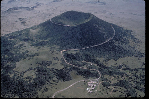
Tomé Hill and surroundings.
AzaniahT, CC BY-SA 3.0 , via Wikimedia Commons
In this month’s exploration of the volcanic landscapes of the Southwest, we turn our attention close to home, showcasing the unique features of Los Lunas, New Mexico! This area is home to some outstanding historical sites and a ton of volcanic features on public lands, and sometimes the two intersect at sites like Tomé Hill.
This unassuming hill of around 380 feet is actually the remnant of a volcano, estimated to have erupted 3.5 million years ago. At this site, lava had burst through a layer of existing rock, leaving behind unique formations where volcanic andesite surrounded and mingled with the existing “country rock.” While the volcano was likely much more prominent in the past, it has been a steadfast landmark for the people of Isleta Pueblo and other Native groups as well as the Hispanic settlers who traversed El Camino Real, the solitary travel route between Mexico City and Santa Fe for hundreds of years. Petroglyphs of both Native and Hispanic creation are a testament to both the prominence of this formation in the surrounding river valley, and the importance of identifiable landmarks in the open desert (Hobbs, 2021; National Park Service, 2020).
Today, this unique site is managed by the Town of Tome Land Grant as a public space. It is also recognized by the National Park Service as a significant site along El Camino Real National Historical Trail. While this is public land, please tread carefully and with great respect, as this site is significant to Native and Hispanic religions and traditions (National Park Service, 2020).
To contact the Town of Tomé, visit https://www.townoftomelandgrant.com/ or call 505-565-0015.
Moving directly west of Tomé Hill, we come across Cerro de Los Lunas. Another volcanic remnant that dominates the skyline in this part of New Mexico, the unusual shape of this small range is actually due to the fact that several eruptions took place in this spot from 3.5 to 1.2 million years ago (New Mexico Museum of Natural History & Science, n.d.; Wilks & Bland, 2013).
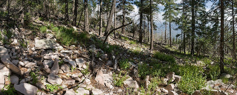
Today, this eruptive landscape has weathered into a fascinating series of cones, depressions, and volcanic rock that make for an interesting (if strenuous) hike. The area was formerly private ranch land recently donated to the Village of Los Lunas, who now manage it as the Cerro de Los Lunas preserve. Though the map and more information aren’t currently available online from the Village, the trailhead can be found on the north side of the preserve, where there is also a sign with a trail map for the area. Hikes range from short 1 to 2-mile out and back routes to a nearly 8-mile loop which approaches the higher summits. While the Village of Los Lunas website is currently not visible, you can reach the Los Lunas Open Space Division at 505-352-7761 (Village of Los Lunas, n.d.).
Use caution when traveling to these areas, and ALWAYS leave them cleaner than you found them—public lands managed by local governments have fewer resources to keep them in good condition. These areas may be close to civilization, but always carry enough water and let others know where you’ll be hiking.
Further Reading
Hobbs, K. (2021, April 14). Postcards From the Field: Cerro de Tomé. Retrieved from New Mexico Bureau of Geology & Mineral Resources: https://geoinfo.nmt.edu/geoscience/research/postcards/home.cfml?id=492
National Park Service. (2020, July 2). New Mexico: El Cerro de Tomé. Retrieved from https://www.nps.gov/articles/000/new-mexico-el-cerro-de-tome.htm
New Mexico Museum of Natural History & Science. (n.d.). Cat Hills-Los Lunas Volcano-Tomé Volcano. Retrieved from https://nmnaturalhistory.org/volcanoes-of-nm/cat-hills-los-lunas-volcano-tom%C3%A9-volcano
New Mexico Museum of Natural History & Science. (n.d.). Los Lunas-Tomé-Black Butte-Los Pinos Volcanoes. Retrieved from https://www.nmnaturalhistory.org/volcanoes/tome-black-butte-los-pinos-volcanoes
Wilks, M., & Bland, D. (2013, Spring). Volcanoes of the Rio Grande Rift. Lite Geology, pp. 5-6. Retrieved from https://geoinfo.nmt.edu/publications/periodicals/litegeology/33/lg_v33.pdf

0 comments