Articles
New Mexico from Space: Valles Caldera National Preserve
3 years ago

Land Management

National Forest Visitor Maps are a valuable resource for travel and recreation within lands administered by this agency. Produced for each of the National Forests (and some more notable wilderness areas) around the country, this series of maps will vary in scale and detail. Luckily, the entirety of the Santa Fe National Forest (which stretches from the Jemez Mountains to the Sangre de Cristos to the east) fits on a single map.
This section of the Santa Fe National Forest Visitor map is centered on the same view from the image above (slightly zoomed in, with north oriented toward the top). This map makes it clear that the area is a complex web when it comes to land ownership, one of the main concerns of recreating on public land.
The Valles Caldera National Preserve, as well as Bandelier National Monument are both administered by the National Park Service and even share a short border. Despite both being under the "Park Service," these sites have different rules and regulations, both from other National Parks and each other.

Looking more closely, the recreation and travel features of these maps begin to unfold. While not topographic, the National Forest maps offer shading to help estimate elevation. More importantly, roads (both in the national forest and out) and trails are shown in detail and with trail numbers (when applicable). Major trail heads and recreation sites get a red badge, denoting a site with amenities provided by the Forest Service, be it an information kiosk, picnic tables, or camping facilities.
Here are just a few of the products we carry that can enhance your outdoor adventures at Valles Caldera:

|
 |
 |
|
Map: New Mexico Recreation Northcentral $9.99 |
Map: Santa Fe, Bandelier, Los Alamos $14.99 |
Hiking Trails in Valles Caldera National Preserve (Revised Edition) |
|
Scale: 1:375,000, $9.99, 2010, reprinted 2022. |
Scale: 1:35,000, topographic, $14.99. 2012. |
Paperback, 173 pages, University of New Mexico Press, $19.95, 2022. |
Natural History
While maps and trail guides might help with finding fun outdoors, they only scratch the surface of the human and geologic history of the area.
Let's zoom out again and take a look at our satellite photo for a different perspective on Valles Caldera:
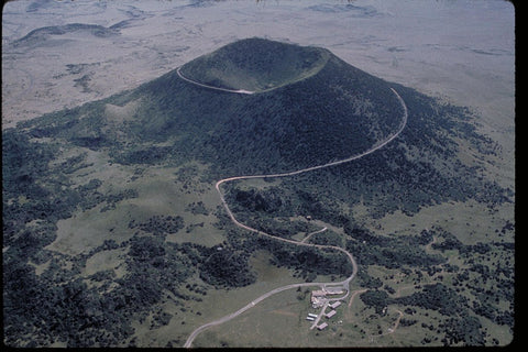
The top half of the image is dominated by the caldera (volcanic crater) for which the preserve is named.
The mesas and canyons are prominent as you follow them down the slopes, but end abruptly in massive cliffs along the Rio Grande, which flows next to the Caja del Rio plateau into Cochiti Lake.
Geologically, this area is fascinating, not only for its volcanic activity, but for the highly visible way that different landforms interact. The red line on this image is the rough path of the Pajarito fault, a geologic feature that marks the western edge of the Rio Grande Rift.
This rift spans nearly the entire state, slowly splitting apart along the river and sinking as the Rio Grande works slowly to erode the earth and deposit sediment. In the process, this action has created some of New Mexico's most remarkable features like the Rio Grande Gorge.
Any visit to the Caldera can be enhanced by learning more about the immense forces that made the landscape possible. Below is a selection of books and maps that describe the geology of this region in great detail:

|
 |
 |
|
Geology of Northern New Mexico's Parks, Monuments, and Public Lands $24.95 |
Map: Valles Caldera National Preserve Guide and Map $17.95 |
Valles Caldera: A Geologic History $18.95 |
|
Published by the New Mexico Bureau of Geology and Mineral Resources, this hefty book is a comprehensive guide to just about every public land site with major geologic features. Learn all about the volcanic and tectonic forces that shaped the landscape through concise yet detailed articles with the amateur geologist in mind. Covers state and federal lands (mainly parks and monuments) from Albuquerque north. A great pick for rockhounds, amateur geologists, or anyone looking for the geologic context behind recreation sites. 372 pages, $24.95, 2010. |
This detailed topographic and geologic map exclusively covers Valles Caldera National Preserve. The front features a close view of the topography, trails, and roads in the monument for navigation. The back features a detailed narrative, diagrams, and maps describing the geologic processes acting on the landscape over time. A good trail map and geologic guide in one. Water and tear-proof synthetic paper. Scale: 1:76,875, $17.95, 2016. |
The first section features a fantastic summary of New Mexico's geologic context and a good primer on geologic principles for any non-geologist. The second section delves into the volcanic, geologic, and natural processes acting on Valles Caldera over time with color photos, rich geological timelines, and maps. Based on the author's 26 years of field work and study on volcanoes and geothermal systems at Los Alamos National Labs, nestled in the shadow of Valles Caldera. 114 pages, University of New Mexico Press, $18.95, 2009. |


0 comments