Articles
Southern New Mexico as Seen from Space
New Mexico's landscapes are extreme in scale, even being visible from space. This single photo from aboard the International Space Station captures fascinating public land sites from above. Featured are: Valley of Fires Recreation Area, White Sands National Park, Lincoln National Forest, and Three Rivers Petroglyph Site.
3 years ago
Photo: Dust storm carrying the fine gypsum of White Sands to the east.
Public Domain, NASA via Wikimedia Commons
This image taken from the International Space Station back in 2012 highlights the massive scale of New Mexico's weather and landforms. The dark Carrizozo Malpais lava flow can be stretching to the northeast, while heavy winds carry the fine gypsum dust from White Sands east over the Sacramento Mountains.
You can encounter the vastly different landscapes in this photo in just one day by visiting your public lands! Keep reading to see a sampling of sites in the frame of this photo.

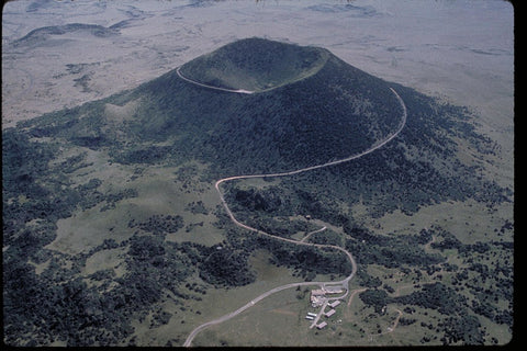
Photo: The Malpais Lava flow at the Valley of Fires Recreation Area.
Public Domain, Bureau of Land Management
The Valley of Fires Recreation Area is managed by the BLM, and offers a chance to get up close and personal with the landscape and wildlife formed by the Carrizozo Malpais lava flow. With an interpretive trail, picnic shelters, and plenty of campsites, this is a great spot to explore the beauty of the desert and the power of volcanism—at one of the youngest lava flows on the continent. We also have our own shop and staff in the visitor center! We'll be glad to help you learn more about the amazing features of the area and recommend nearby spots to recreate.

Photo: Dunes at White Sands National Park
Public Domain, National Park Service via Wikimedia Commons
White Sands National Park is one of the jewels of southern New Mexico, for good reason. This landscape of gypsum dunes is constantly shifting, and creatures living here have developed unique adaptations that allow them to survive this intense environment. The only camping in the Park is at dispersed backcountry sites, by permit only. Even without an overnight stay, a long day of sledding down dunes and hiking the seemingly endless hills is sure to be a memorable experience.

Photo: The Sitting Bull Falls in the Lincoln National Forest
Public Domain, USDA Forest Service, Lincoln National Forest
The Sacramento Mountains are heartlands of the Mescalero Apache Tribe, whose present-day lands are bordered to the north and south by the Lincoln National Forest.
The tribe notes on their website that: "The Mescalero roamed freely throughout the Southwest including Texas, Arizona, Chihuahua, México and Sonora, México," and that "today, three sub-tribes, Mescalero, Lipan and Chiricahua, make up the Mescalero Apache Tribe. We live on this reservation of 463,000 acres of what once was the heartland of our people’s aboriginal homelands."
The towns of Ruidoso and Cloudcroft near the reservation are home-base for many visitors to the area, serving as a hub for activities like skiing, mountain biking, and hiking. The high elevations make this area a "sky island" of relatively wet forested peaks among the dry stretches of the Chihuahuan Desert that surround the Sacramentos. Countless developed campsites and spots for dispersed camping within the National Forest make this one of the best (and most popular) places for forest fun in southern New Mexico, attracting visitors from surrounding states.

Photo: Petroglyphs at the Three Rivers Site near Tularosa.
Public Domain, National Archives and Records Administration via Wikimedia Commons
One more site that's not quite visible from space (but equally important nonetheless) is the incredible Three Rivers Petroglyph Site. Scattered across several dozen acres managed by the Bureau of Land Management, thousands of individual glyphs carved over a period of over a thousand years mark this site as one of great importance.
The Jornada Mogollon people once settled throughout the Tularosa Basin, including areas within White Sands. This group subsisted on the limited runoff from rains for farming and by utilizing the large salt deposits in the area for food preservation and trading. While this culture group disappears from the record about 600-700 years ago (possibly moving to find a more stable climate for long-term settlement), their artworks and remnants of daily life still inspire visitors to the area today.


0 comments